PATENED COLORIZATION TECHNOLOGY
Create High Resolution Color Images Using R2V's Image Fusion Technologies
Remote sensing technology provides a wide variety of image
sources covering the surface of the earth at different time,
spatial resolution, and in different wavelength. The
wavelengths used in
remote sensing satellites can range from
infrared to visible to thermal. R2V provides a new technology to create high resolution image
fusion output by utilizing the high spatial resolution of single
band images, such as SPIN-2, and the rich spectral information of
low spatial resolution image, such as LANDSAT TM.
Acknowledgements:
The raw image data (LANDSAT TM and SPIN-2) used to create the sample images are provided by the US Government through Eastman Kodak Company as part of the Multi-Modality Image Fusion Study project and are used here with their permission.
How to colorize a high resolution grayscale image using low
resolution multi-spectral images?
This image fusion method is implemented based on US Patent #6,477,270. Please contact us directly if you are interested in licensing this technology.
Step 1: Image preparation
If the source image is not a standard format, use the File/Import Raw Image command to import the image and save it to a standard image file format, such as TIFF.
Register the low resolution color or multi-spectral image against the high resolution, grayscale image, using R2V's Image/Warp command. Apply this to all individual image bands that are going to be used.
Use R2V's Image/Crop Region command to cut the registered low resolution color image to make it cover the same area as the high resolution grayscale image. Apply this to all image bands.
Save each cropped image to a new image file using the File/Save Image command
This image example shows the registered LANDSAT TM image band
2 in the San Francisco area.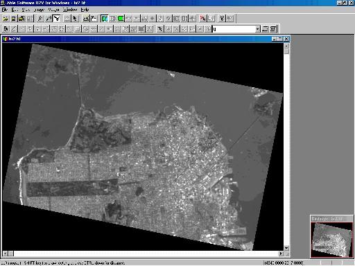
Step 2: Image fusion to colorize the grayscale image
-
Start the Image/Colorize command
-
Enter the name of the grayscale image and the names of the three prepared low resolution color image bands. The bands will provide red, green, and blue color information in the fusion process and they can be organized differently to create different color effects
-
Click "OK" to finish the image fusion process. The new colorized image will be displayed in an image window. Use File/Save Image to save this true color image to a file or continue for more processing, such as color classification, or raster to vector conversion to create vector based maps.
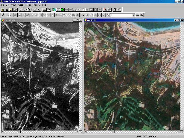
The figure below shows the original high resolution grayscale image and the R2V colorized image for the Golden Gate Recreation Area in San Francisco, CA. Vegetation, roads, buildings, ponds, water, and other ground objects can now be seen clearly in the colorized image and much higher accuracy can be achieved in image analysis and interpretation.